Navigation & Weather

Maps Delos - Mykonos - Rheneia Hiking Map Maps Delos - Mykonos - Rheneia Hiking Map 2
In Stock
7.00 €
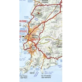
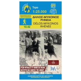
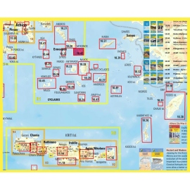
Hiking map of Mykonos, Delos & Rheneia islands in a scale of 1:25.000. Mykonos (Mikonos) with the nearby islands of Delos (Dilos or Délos in French) and Rheneia (Rineia, Rinia or Rhénée in French) on a light, waterproof and tear-resistant, GPS compatible map at 1:25 000. The reverse side shows a large, very detailed plan of the archaeological remains...
Maps Zagori - Valia Kalda - Metsovo Hiking Map Maps Zagori - Valia Kalda - Metsovo Hiking Map 2
In Stock
Hiking map for Zagori, Valia Kalda and Metsovo in a scale of 1:40 000. Zagori - Metsovo - Valia Kalda 1:40 000 map comprises all recent outdoor activity in the area. More than 10 mountain professionals collaborated for its update. This map is really the necessary tool for anyone traveling in the area. It does not replace Zagori 1:50 000 which has trail...
Maps Cyclades - Argosaronic Road & Touring Map Maps Cyclades - Argosaronic Road & Touring Map 2
In Stock
Touring map of Cyclades and Argosaronic in a scale of 1:200 000. The map of Cyclades - Argosaronic covers the areas of Attica with the Argosaronic islands of Salamina, Aegina, Ydra and Poros and all the Cyclades islands, printed on 2 sides with overlap. A very useful map, especially for island-hoppers, with short text for each island presenting the main...
Maps Lefka Ori (White Mountains) - Sfakia/Pahnes Hiking Map Maps Lefka Ori (White Mountains) - Sfakia/Pahnes Hiking Map 2
In Stock
Hiking map for Lefka Ori , Sfakia , Pahnes in a scale of 1:25.000. The new map covers the whole mountain range of Lefka Ori from its northern foothills to the Libyan Sea (Sfakia). All the hiking routes that crisscross the mountain (including the E4 trail) are clearly marked on the 1:25.000 map. On the back side of the map there are short descriptions and...
Maps Psiloritis Hiking Map Maps Psiloritis Hiking Map 2
In Stock
Maps

Psiloritis Hiking Map

AN11.14
8.50 €
Hiking map of Ida (Psiloritis) mountain in a scale of 1:30.000. Mt Psiloritis dominates the center of the island and the hearts of the Cretan people. It is an imposing, steep and rugged mountain, the place of upbringing of Zeus, of the Cretan wild goats and the unconquered Cretan soul. Trails climb from all sides to the highest peak where there is a stone...
Maps Geopsis Agrafa Hiking Map Maps Geopsis Agrafa Hiking Map 2
In Stock
10.00 €
This two-sided map presents the the broader Agrafa area. At 1:50.000, it covers: North Agrafa, East Agrafa, West Agrafa, Argithea, Voulgara, Lake Plastira, Lake Kremaston, Lake Stefaniada, Achelous area, Agrafiotis, Megdovas, Rentina, Fourna, Amarantos etc.
Maps Pelion Hiking Map Maps Pelion Hiking Map 2
In Stock
Maps

Pelion Hiking Map

AN4.3-4.4
9.50 €
The hiking map of Pilio - Mavrovouni in scale 1:45 000 covers the whole Pilion peninsula and Mt Mavrovouni a natural continuation of Mt Pelion to the north. Twenty highlighted hiking routes among dozens of recorded footpaths are proposed.The mountainous Pelion peninsula is gifted with abundant forests, waters, fruit trees, stone-paved trails, excellent...
Maps Kalymnos Hiking Map Maps Kalymnos Hiking Map 2
In Stock
Maps

Kalymnos Hiking Map

AN10.32
6.00 €
Kalimnos (also written Kalymnos or Calymnos) is an island of the Dodecanese archipelago, and climbing destination of the Mediterranean with more 2000 climbing routes. Kalimnos hiking map is waterproof and tear-resistant. The map shows all hiking trails and rock climbing sites.
Maps Ikaria Hiking Map Maps Ikaria Hiking Map 2
In Stock
Maps

Ikaria Hiking Map

AN10.51
8.50 €
The new Anavasi map of Ikaria on a scale of 1:35.000 figures dozens of footpaths, the complete road network and all the beaches of the island, which is also well known for its summer feasts (panigiria) and the longevity of its inhabitants.
Maps Lemnos Hiking Map Maps Lemnos Hiking Map 2
In Stock
Maps

Lemnos Hiking Map

AN10.30
6.50 €
A new detailed hiking map for Lemnos in scale 1:60 000 by Anavasi editions with information on its monuments and beaches.
Maps Agrafa Hiking Map Maps Agrafa Hiking Map 2
In Stock
Maps

Agrafa Hiking Map

AN2.5/4.1
9.50 €
Ηiking map of Agrafa Mountains printed on polyart paper. Scale 1:50000.
Product added to wishlist
Product added to compare.

We use cookies to improve user experience. Click Accept if you accept our cookies policy - privacy policy